DYNPLOT - Graphical User Interface
- DYNPLOT is the core graphical user interface for DYNSYSTEM.
- DYNPLOT is designed to assist in development of conceptual and numerical models
- DYNPLOT has extensive geographic data display capabilities in plan view and cross-section
- DYNPLOT can be used in spatial visualization of contaminant data
- DYNPLOT has extensive model building capabilities
In addition, DYNPLOT has sub-modules for specialized data interpolation and other functions. DYNPLOT interacts with data management codes (such as ACCESS or ORACLE), with Arc/Info files, and with AutoCAD drawings.
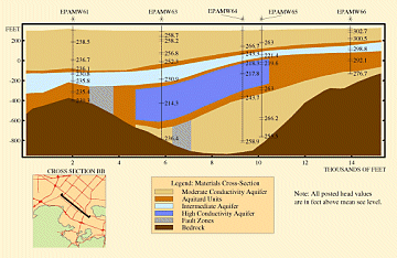
Example Vertical Cross-Section in DYNPLOT
(Click image for larger view)


